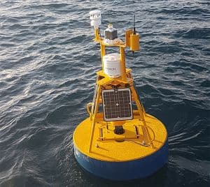
TASCAM is a hi-tech coastal monitoring buoy that collects physical and biological data in Tasman Bay, New Zealand.
What is TASCAM?
The TASCAM coastal monitoring platform was the first buoy in New Zealand waters to use inductive instrument technology. This hi-tech buoy was developed in collaboration with the California-based Monterey Bay Aquarium Research Institute (MBARI). TASCAM stands for the Tasman Bay Cawthron and MBARI mooring.
What does it do?
TASCAM records long-term information on simple but significant parameters like temperature, salinity, turbidity (sediment) and chlorophyll – all indicators of the quality and productivity of our coastal waters.
Located in western Tasman Bay, TASCAM is situated to build on the wealth of knowledge gained during the multi-year Integrated Catchment Management research programme for the Motueka river catchment. However, the long-term intention is that TASCAM, and others bouys like it, will form a nationwide network that provides integrated information on New Zealand’s waters.
Who uses the data?
The aim of TASCAM is to meet the needs of multiple stakeholders. It provides information on the local marine environment not only for researchers and local councils, but also day-to-day end users such as marine farmers and recreational fishers.
How often is data updated?
Data is downloaded on an hourly basis at the top of the hour. Plots are generated automatically and uploaded to the site at 15 and 20 minutes past the hour.

Left – TASCAM in operation in the waters of Tasman Bay, New Zealand.
Paul Barter
Scientist – Environmental Impact Assessments & Aquatic Technology
